Log in
All resources
Create a design
6,143 Free Images of Map Symbols
bibliothèque nationale de france
girolamo porro
1600 world map by girolamo porro
leonardo cernoti
drawings in the museu antônio parreiras
map - museu antônio parreiras
antônio parreiras
paper and graphite
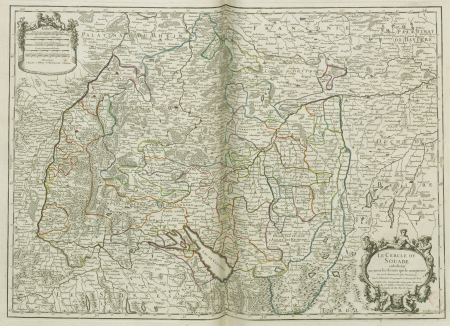
map of the circle of swabia by sanson
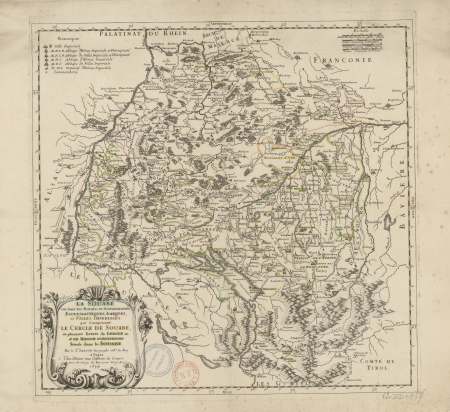
map of the circle of bavaria by sanson
stadhuis haarlem in art
1689 map of haarlem
maps by girolamo porro
liburnia
curt teich postcard archives
map postcards
map of ghent by jan blaeu
sint-lievenspoort (ghent)
curt teich postcard archives
map postcards
curt teich postcard archives
map postcards
map postcards
reg manning
map of amsterdam, 1544
d as an initial
sheet 11 of the turgot map of paris
rue neuve-notre-dame (paris)
map of the circle of swabia by sanson
bibliothèque nationale de france
map of the circle of bavaria by sanson
bibliothèque nationale de france
map of the circle of swabia by sanson
bibliothèque nationale de france
map of the circle of franconia by sanson
bibliothèque nationale de france
map of the circle of swabia by sanson
bibliothèque nationale de france
map of the circle of bavaria by sanson
bibliothèque nationale de france
map of the circle of franconia by sanson
bibliothèque nationale de france
map of the circle of swabia by sanson
bibliothèque nationale de france
map of the circle of austria by sanson
bibliothèque nationale de france
map of the circle of franconia by sanson
bibliothèque nationale de france
map of the circle of bavaria by sanson
bibliothèque nationale de france
map of the circle of swabia by sanson
bibliothèque nationale de france
map of the circle of bavaria by sanson
bibliothèque nationale de france
map of the circle of austria by sanson
bibliothèque nationale de france
map of the circle of bavaria by sanson
bibliothèque nationale de france
map of ghent by lucas de heere
lucas de heere
map of ghent by armand heins, 1911-1912
armand heins
1600 world map by girolamo porro
leonardo cernoti
1600 world map by girolamo porro
leonardo cernoti
15th-century maps of the caucasus
fra mauro map details
1600 world map by girolamo porro
leonardo cernoti
17th-century maps of iceland
iceland map by joris carolus
1600 world map by girolamo porro
leonardo cernoti
1600 world map by girolamo porro
leonardo cernoti
1600 world map by girolamo porro
leonardo cernoti
1600 world map by girolamo porro
leonardo cernoti
works after map of amsterdam, 1544
george willem hendrik panchaud
1600 world map by girolamo porro
leonardo cernoti
1600 world map by girolamo porro
leonardo cernoti
reconstruction of ruysch's africa map by stanley
nell'africa tenebrosa (1890)
1600 world map by girolamo porro
leonardo cernoti
17th-century maps of iceland
iceland map by joris carolus
old maps of scotland from the norman b. leventhal map center
old maps of ireland from the norman b. leventhal map center
maps of paris from the david rumsey historical map collection
maps of paris by caspar merian
15th-century tempera paintings of men
portrait paintings of standing men
john rocque's 1746 map of london
details of old maps of london
amsterdam in the 1540s
agnietenkapel
van langren map of southeast asia
renaissance
map of paris by claes jansz. visscher
penn state university libraries
drawings in the museu antônio parreiras
paper and graphite
ptolemy's 4th african map
1477 maps
drawings in the museu antônio parreiras
paper and graphite
drawings in the museu antônio parreiras
paper and charcoal
drawings in the museu antônio parreiras
paper and graphite
drawings in the museu antônio parreiras
paper and graphite
ptolemy's 4th asian map
1470s maps of palestine
drawings in the museu antônio parreiras
paper and graphite
drawings in the museu antônio parreiras
paper and graphite
old maps of haarlem
museum haarlem
paintings in the wien museum
ignaz unterberger
symbols of königshütte (królewska huta)
ignatius taschner
julius magnus petersen
city seals of denmark
50 state quarter (new jersey)
romanticism
50 state quarter (new jersey)
romanticism
truscott map of st-petersburg 1753
german quarter
arnold van langren map of southwest africa
renaissance
ferdinand joseph nautz
old maps of haarlem
dheulland map of paris
maps by a. taride
john rocque's 1746 map of london
bibliothèque nationale de france
territorium argentoratense (1652 map)
context files from gallica
maps of paris from paris musées
dheulland map of paris
maps of paris from paris musées
dheulland map of paris
john rocque's 1746 map of london
bibliothèque nationale de france
john rocque's 1746 map of london
bibliothèque nationale de france
territorium argentoratense (1652 map)
context files from gallica
mercator 1587 world map
maps by jodocus hondius
1600 world map by girolamo porro
leonardo cernoti
1600 world map by girolamo porro
leonardo cernoti
david rumsey historical map collection
1790s maps of the holy roman empire
symbol
maps
propaganda map
1529 maps
1689 map of haarlem
1688 in haarlem
propaganda map
1529 maps
maps of haarlemmerhout
old maps of haarlem
symbols of smolensk with gamayun and cannon
alexey zubov
maps of amsterdam in the rijksmuseum amsterdam
map of amsterdam, 1544
latin-language maps
bologna ptolemy
hendrik van langren map of south asia
1590s maps of india
demolished churches in de barbari map
santa croce ex-church (venice)
demolished churches in de barbari map
santi filippo e giacomo (venice)
maps in the stadsarchief amsterdam
works after map of amsterdam, 1544
allegories of liberty in argentina
salón blanco
maps from gallica
propaganda map
drawings in the museu antônio parreiras
paper and graphite
drawings in the museu antônio parreiras
paper and charcoal
r. hausermann, carte de la terre sainte, 1914
eran laor cartographic collection
drawings in the museu antônio parreiras
paper and charcoal
drawings in the museu antônio parreiras
paper and graphite
fra mauro map details
maps of colchis
drawings in the museu antônio parreiras
paper and graphite
r. hausermann, carte de la terre sainte, 1914
eran laor cartographic collection
2101 - 2200 of 6,143
Next page
/ 62


![The Circle of Bavaria subdivided into all the States which compose it / by Mr. Sanson, ,... A thousand geometric steps or Miles of Italy [30 = 12] common leagues of France, 1703](https://cdn.creazilla.com/illustrations/10000537444/the-circle-of-bavaria-subdivided-into-all-the-states-which-compose-it-by-mr-sanson-a-thousand-geometric-steps-or-miles-of-italy-30-12-common-leagues-of-france-1703-sm.webp)